‘It ripped right down the street’
By CRAIG D. SCHENCK/Sentinel staff
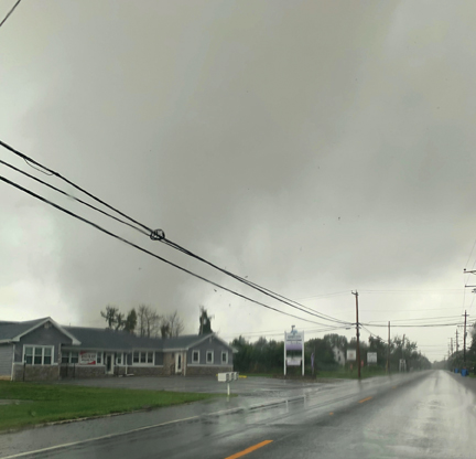
UPPER TOWNSHIP — The National Weather Service in Mount Holly confirmed Tuesday it had received reports of a tornado touching down in the Strathmere section of Upper Township.
Meteorologist Patrick O’Hara said he could not confirm anything early Tuesday afternoon but that the office had received reports of a possible tornado. He also said there were reports of wind damage to the Montego Bay Resort in North Wildwood, as well as trees down at mile markers 4.5 and 22 on the Garden State Parkway.
There were numerous reports and photos of damage and sightings of a funnel cloud in other parts of Upper Township.
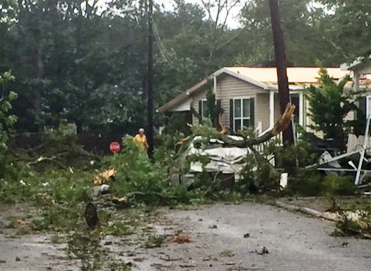
Lois Hughes, a resident of Barrington Road in the Pine Hill Mobile Home Court, said the ordeal was frightening.
“It ripped right down the street and caused so much damage, flipped over sheds, ripped off steps, ripped off an enclosed porch, then it went to our car and smashed out a window down the street,” Hughes said, still a bit shaky from fright. “All of the trees — you can see the line where it went down, it snapped the tops of the trees off. There are big limbs coming down across the street.”
O’Hara said a storm spotter reported seeing flying debris and said it very likely was a tornado.
Erik Weeks, a bartender at the Deauville Inn in Strathmere, said he saw a funnel cloud in Corson’s Inlet.

“It touched down on the north side of the bridge, went up the marshes in front of Boulevard Super Liquors,” Weeks said. “It went racing across the little road between Ocean City and Strathmere and headed toward 34th Street.”
Meteorologist Nick Carr later confirmed the tornado’s existence.
“There was a tornado that touched down near Strathmere in Cape May County,” he said, adding that it was in Strathmere Bay at about 9:50 a.m. and made it to the mainland toward Ocean View. “We haven’t received much report of damage but there was debris in the air.”
The National Weather Service had issued a tornado watch at 7:23 a.m. Tuesday for Cape May, Cumberland and Salem counties. This came amid a tropical storm warning for Atlantic and Cape May counties. The National Weather Service then issued a tornado warning from 9:45 to 10:15 a.m. in the counties.
“Tropical Storm Isaias is passing over Delmarva and will continue to track northward, and then northeastward along the East Coast of the United States. Isaias will lift north of the region by early this evening. Impacts will diminish from late this afternoon into tonight,” the National Weather Service reported. “The main threats with this system are heavy rain resulting in widespread flash flooding as well as river flooding, and strong to damaging winds, especially near the coast. Tornadoes will continue to affect the region. In addition, minor to potentially moderate coastal flooding and dangerous marine conditions will occur.”
The area was expected to receive 4 to 6 inches of rain, as well as wind gusts of 65 to 75 mph along the coast and 50 to 60 mph inland.

Local officials were surveying damage early Tuesday afternoon and weren’t available for comment at the Sentinel went to press.