Cape May County to roll out ‘Know Your Zone’ with updated map for officials, residents and visitors to prep for future storms
CAPE MAY COURT HOUSE — Hurricane season in Cape May County requires officials and residents to keep a close watch as dangerous storms develop and progress up and along the East Coast.
That is especially true during the height of the summer tourism season when the county’s population increases exponentially as visitors swarm the shore communities.
However, what takes place when the season is over can be just as important as what happens during the storms.
Cape May County’s Office of Emergency Management (OEM) takes that approach. The county OEM works closely with OEM offices from Ocean City to Cape May planning for events they hope never come to pass.
Making sure the individual communities, especially on the barrier islands, are storm-ready is key to having critical plans in place for when hurricanes and nor’easters approach.
One of the major concerns, and one that is rarely used, is evacuating the county. The last time it happened was nearly 15 years ago and it was a major event unto itself that cut the summer tourism season short.
On Aug. 25, 2011, as Hurricane Irene powered its way north along the East Coast, then-Gov. Chris Christie declared a state of emergency. Cape May County’s OEM director at the time, the late Frank McCall, ordered an evacuation.
Within two days, the governor said, 90 percent of the people in Cape May County had evacuated, which press reports put at more than 500,000.
Hurricane Irene largely spared the county from severe damage because of where it made landfall. Such was not the case a little more than a year later with Hurricane Sandy, when evacuation was initially voluntary.
Getting those people out of a county bordered on one side by the Atlantic Ocean and on the other by Delaware Bay wasn’t an easy task, but it was successful in 2011.
County officials have not been content to rest on their laurels even though the county was the first in the state to be designated “StormReady” by the National Weather Service.
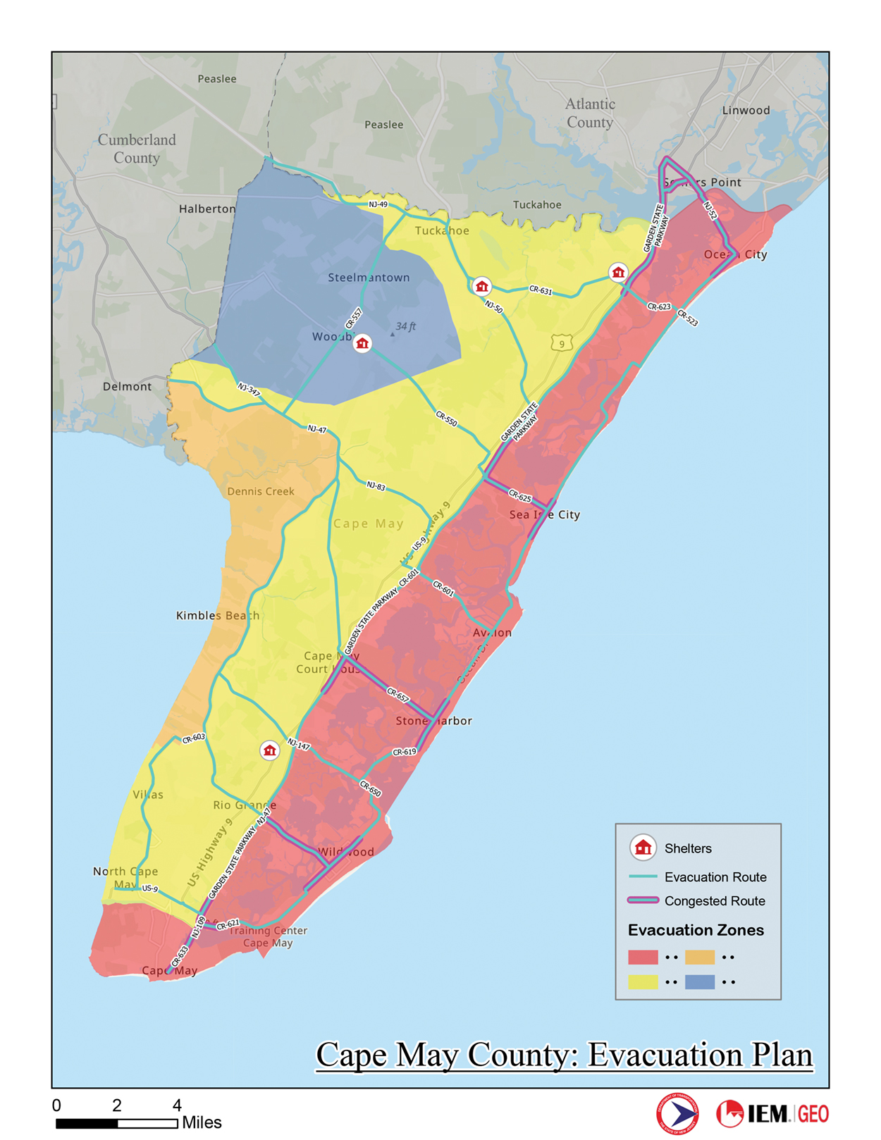
On Dec. 16, current Cape May County OEM Director Chris Leusner presented the county’s Board of Commissioners with an updated evacuation plan, one that includes four primary zones and shows the routes to be taken.
The evacuation plan has to align with federal requirements and that coastal evacuation has to be in alignment and integrated with the New Jersey State Emergency Operations Plan. Because of the volume of traffic in this densely populated state, evacuation plans have to be efficient in the way they use the roadways, shelters, public safety personnel and transportation assets.
Local municipalities can incorporate their own evacuation plans into the county plan.
According to Leusner, there are four zones, including the one for the most vulnerable parts of the county — the barrier islands, including Cape Island, and residents who live to the east of the Garden State Parkway.
The four zones are:
— Zone A: The barrier island and oceanfront communities most vulnerable to early and severe storm surge, such as Ocean City, Sea Isle City, Avalon, Stone Harbor, the Wildwoods, Cape May, West Cape May and Cape May Point. These areas represent the first tier for mandatory evacuation during serious storm threats due to life-threatening surge risk and potential isolation from causeway closures.
— Zone B: The 100-year storm surge areas, primarily bayside communities in parts of Lower, Middle and Dennis townships, which may experience significant flooding during stronger or prolonged events.
— Zone C: Extended coastal and inland flood hazard areas across portions of the townships of Lower, Middle, Dennis and Upper, where access and infrastructure damage may occur during extreme storms.
— Zone D: Including Woodbine Borough and portions of Dennis Township that face comparatively lower surge risk but may still be affected during the most severe events and may serve as sheltering or reception areas depending on state guidance.
According to a release issued by the county, which detailed the zones listed above, the evacuation analysis took into account multi-hazard risks, evacuation demand from neighboring counties, designated shelter locations and real-world traffic flow on the region’s transportation network.
The county plans to have information available on its website with a “Know Your Zone” guidance for residents so they can familiarize themselves with their evacuation route long before dangerous storms approach.
“These evacuation zones give us a clear, consistent framework that aligns local decision-making with state and federal planning tools,” Leusner stated in the county’s release. “When residents know their zone ahead of time, they are far better prepared to act quickly and safely when evacuation guidance is issued.”
“Public safety depends on preparation and communication,” Board of Commissioners Director Leonard Desiderio said. “By adopting these standardized evacuation zones, Cape May County is strengthening its ability to protect residents and visitors while ensuring our response is fully coordinated with state agencies during major storm events.”
– By DAVID NAHAN/Sentinel staff